Synopsis:
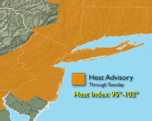
The heatwave will continue as high pressure sits over the Eastern seaboard. The heat should persist through midweek. The combination of temperatures over 90º and high levels of humidity will result in a heat index in of 95º to 100º through Tuesday. The heat index will reach 100º-102º over parts of NJ on Tuesday. For this reason, a Heat Advisory has been posted through Tuesday.
A spot afternoon and or evening storm is possible Tuesday with a weak disturbance moving through.
A cool front will approach the area Wednesday with scattered showers and storms later in the day and at night. Relief will arrive on Thursday. Temperatures and humidity levels will be lower.
Stay tuned.
Today:
Hazy, hot and humid. Highs in the lower to mid 90s. Southwest winds at 5-10mph.
Tonight:
Clear, muggy and warm. Lows in the upper 70s in the City, closer to 70º inland. South to Southwest winds 5mph.
Tuesday:
Hazy, hot and humid. Spotty late day storms. Highs in the lower 90s.
Wednesday:
Hazy, hot and humid. Afternoon showers and storms. Highs in the lower 90s.
Thursday:
Mostly sunny, warm and much less humid. Highs in the mid to upper 80s.
Friday:
Party sunny and warm. Highs in the mid to upper 80s.
Keep it here for a no nonsense, no hype forecast.