Synopsis:
High pressure will be in control through the weekend. At first, the high will keep the airmass over the region comfortable as it moves off the New England coast. But later in the weekend, the winds will turn to the South around the high and bring up an increasingly humid airmass. A few showers or storms are possible Saturday Night into early Sunday morning with a disturbance moving through.
It’ll be hot Sunday through Tuesday with readings around 90º.
Stay tuned.
Today:
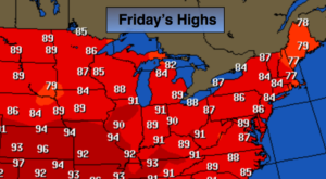
Sunny. Highs in the mid 80s. Northeast to Southeast winds at 5-10mph.
Tonight:
Partly cloudy. Lows around 70º in the City, the 60s inland. South wind less than 5mph.
Saturday:
Partly sunny.. Highs in the mid 80s.
Sunday:
A spotty early shower or storm, otherwise hazy, hot and humid. Highs around 90º.
Monday:
Hazy, hot and humid. Highs in the lower 90s.
Tuesday:
Hazy, hot and humid with afternoon thunderstorms. Highs around 90º.
Keep it here for a no nonsense, no hype forecast.