Synopsis:
A weak front will move in tonight with isolated thunderstorms. Not all areas will get wet. It’ll be humid for the first part of the night. Behind the front on Thursday you’ll notice a dramatic decrease in the humidity. It’ll warm and breezy under partly sunny skies.
Friday will be a winner as high pressure moves in.
The weekend will be Summer-like with plenty of sunshine. Father’s Day will be mostly sunny with highs well into the 80s with higher humidity.
Monday will be sizzling with readings into the 90s.
Stay tuned.
Tonight:
An isolated shower or storm otherwise mostly clear and becoming much less humid late. Lows in the mid 60s in the City, the upper 50s inland. Southwest to West winds at 5-10mph.
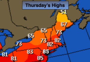
Thursday:
Partly sunny, breezy and warm. Much more comfortable. Highs in the mid 80s. West winds at 15-25mph with higher gusts.
Friday:
Mostly sunny. Highs around 80º.
Saturday:
Sunny. Warm. Highs in the mid 80s.
Sunday:
Mostly sunny, very warm and humid. Highs in the mid to upper 80s.
Monday:
Hazy, hot and humid. Highs in the mid 90s.
Keep it here for a no nonsense, no hype forecast.