Synopsis:
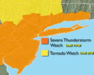
A Severe thunderstorm Watch has been posted until 11pm. Severe thunderstorms are defined as storms with winds in excess of 58mph and or 3/4″ hail. Flash flooding is a possibility as well, as the models are hinting at slowly recurring storms. Please keep an eye to the sky after 4pm and through the evening hours. Seek shelter immediately if threatening weather looks imminent.
Wednesday will be much cooler with cloudy skies and on and off showers as the front slip to the South. A bit of sun may shine on thursday but the threat of showers remains.
The stationary front will become a strong warm front and move toward the area on Friday. The ingredients are there for the potential of more heavy rain and thunderstorms later in the day.
At this time the weekend looks unsettled with showers and thunderstorms on Saturday and a slight chance on Sunday. Sunday looks to be the drier of the two days at this time.
Stay tuned.
Into This Evening & Tonight:
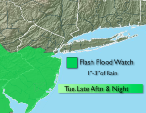
Showers and thunderstorms developing later this afternoon and through this evening. Some of the storms maybe severe. Remaining mostly cloudy once the storms move through. Lows in the upper 50s to lower 60s. Northeast winds at 5mph.
Wednesday:
Cloudy. Much cooler with periods of rain. Highs in the mid 60s. Northeast 5-10mph.
Thursday:
Early showers. Some late day sun possible. Highs in the mid 70s.
Friday:
Cloudy with periods of rain and thunderstorms, much cooler. Locally heavy rain. Highs in the mid 60s.
Saturday:
Mostly cloudy with scattered showers and thunderstorms. Highs in the lower 70s.
Sunday:
Sun and clouds with isolated showers and thunderstorms. Highs in the mid 70s.
Keep it here for a no nonsense, no hype forecast.