Synopsis:
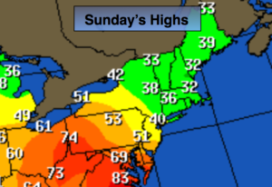
A wild ride in temperatures has occurred this weekend. It went from Summer to Winter within half a day. Temperatures have dropped more than 40º. Welcome to the crazy season of Spring in the Northeast. It will be a shock to many after Saturday’s very warm readings. A cold front has pushed South to near the DC area. A stiff, cold wind will blow off the Atlantic resulting in clouds and well below average temperatures today. Moisture will build with the oceanic flow and areas of drizzle and light rain will develop this afternoon.
Tonight, as weather systems begin to converge on the tri-state area periods of rain are likely. The front will move North as a warm front and readings will rise well after midnight.
A period of heavy rain and thunderstorms is likely Monday morning as a deep Southern flow ahead of a cold front works in. One to two inches of rain is possible during the morning commute through midday. Flooding of streets and highways is possible. Once the front moves through midday the rain will taper off to scattered showers and there maybe some occasional peeks of sun. It will be mild.
Temperatures will remain cooler than average into midweek.
Stay tuned.
Today:
Cloudy, breezy and cold. Areas of drizzle and spotty showers developing during the afternoon. Highs only in the 30s to around 40º. East to Northeast winds at 15-30mph.
Tonight:
Periods of rain and drizzle. Breezy. Temperatures rising into and through the 40s well after midnight. East to Northeast winds at 15-30mph.
Monday:
Rain, possibly heavy at times in the morning with scattered thunderstorms. Scattered showers in the afternoon. Highs around 60º.
Tuesday:
Mostly cloudy with scattered afternoon showers. Cool. Highs around 50º.
Wednesday:
Mostly sunny. Highs in mid to upper 50s.
Thursday:
Mostly cloudy. Chance of afternoon showers. Highs in mid to upper 50s.
Keep it here for a no nonsense, no hype forecast.