Synopsis:
A wild ride in temperatures will occur this weekend. Most areas will feel like early Summer today. By tomorrow, it’ll feel more like Winter. Welcome to the crazy season of Spring in the Northeast.
An area of high pressure off the Southeast will be responsible for our June-like readings today. A Southwest wind will bring temperatures up to levels that will make most happy today.
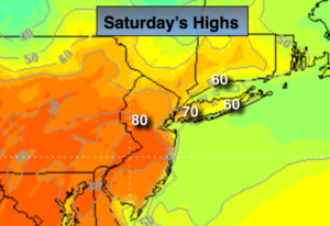
A backdoor cold front will be moving Southwest through the region this afternoon. The big question is how far Southwest does the front get? There will be a dramatic temperature difference for the tri-state area. It will be June-like on the warm side of the front and much cooler to the Northeast of the front. No matter how you slice it today will still be a warm day for many areas. To the North and East of the City readings will most likely be much cooler due to the wind coming off the colder Atlantic. The map above shows 80’s over inland and Western areas to the 60s over Long Island and Coastal areas of Connecticut and NJ. As the front moves inland you will notice a dramatic drop in temperatures later this afternoon.
The second half of the weekend will feel more like Winter. This will result in a much colder day and will be a shock to many after Saturday’s very warm readings. Scattered showers or areas of drizzle are likely on Sunday.
A significant rain is likely on Monday morning as a deep Southern flow ahead of a cold front works in. Once the front moves through midday the rain will taper off to scattered showers and there maybe some occasional peeks of sun.
Temperatures will remain cooler than average into midweek.
Stay tuned.
Today:
Partly sunny. Highs in the 70s to lower 80s over inland NJ to the 50s and 60s over Northeastern areas and at the coast. Southwest to Southeast winds increasing to 10-20mph.
Tonight:
Mostly cloudy and breezy. Turning much colder. Scattered showers and areas of drizzle. Lows around 40º in the City, the 30s inland. Southwest winds at 10-15mph. East to Northeast winds at 15-25mph.
Sunday:
Mostly cloudy and much colder than Saturday. Areas of drizzle and spotty showers. Highs only in the 30s to around 40º.
Monday:
Rain, possibly heavy at times in the morning. Scattered showers in the afternoon. Highs around 60º.
Tuesday:
Mostly cloudy. Cool. Highs around 50º.
Wednesday:
Partly sunny. Highs in mid to upper 50s.
Keep it here for a no nonsense, no hype forecast.