Synopsis:
It definitely won’t feel like Spring though early this week. Readings will be more than ten degrees below average for highs. The average high is in the upper 50s. High pressure will result in a bright but chilly start to the workweek. This flow out of Canada has been responsible for the very cold start to Spring. There is a chance of a bit of wet snow or rain tonight into Tuesday with a storm passing well Southeast of the region. A coating of snow is possible well inland by Tuesday morning.
Looking down the pike more seasonal Springtime temperatures will be with us later this week and into the beginning of the weekend as high pressure moves off the Southeast coast. A Southwest wind should bring temperatures up to levels that will make most happy.
Stay tuned.
Today:
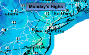
Sun to clouds. Highs in the mid 40s. Northwest to South wind at 5-10mph.
Tonight:
Cloudy with areas of light snow or rain developing. Lows in the mid 30s in the City, near 30º inland. Southwest to Northeast winds at 5mph.
Tuesday:
Mostly cloudy with wet snow or rain showers. Highs in the mid to upper 40s.
Wednesday:
Mostly sunny. Milder. Highs in the mid 50s.
Thursday:
Partly sunny, more seasonal. Highs around 60º.
Friday:
Partly sunny. Much warmer. Highs around 70º.
Keep it here for a no nonsense, no hype forecast.