Synopsis:
A persistent Northwesterly flow will continue resulting in colder than average temperatures right through the weekend. The culprit, a stationary storm in Eastern Canada and high pressure nosing in from central Canada. Sunny skies are expected for the last weekend of Winter (that sounded good). Winds will not be as busy.
The latest computer guidance is now converging on a scenario for this upcoming week in regards to areas of low pressure affecting the East coast. A developing storm will move out of the Tennessee Valley on Monday and move off the Virginia coast and to the Northeast on Tuesday- up and off our coast. This increases the threat of snow, rain and sleet from NYC and to the South on Tuesday. There will be a sharp cutoff to the precipitation on the Northern edge. Where this cutoff sets up is still in question. Will it clip the City and vicinity or will it remain South? An accumulating snow is possible if the heavier rates of snow occur. Also, the sun angle will play into the equation of how much snow will stick during the daylight hours (it has to snow at a very good rate for snow to accumulate during the day).
A second storm now looks to develop with additional energy in the jet stream diving South into the Carolina’s. The storm will form East of the Outer Banks on Wednesday. Will the upper level winds sharpen up enough to have this storm affect the area. The possibility is slim at this point. Gusty winds and coastal flooding is a possibility with a persistent Northeast wind Tuesday through Thursday.
In summary, there will be two separate storms. One that may clip parts of the area (mainly South) on Tuesday the other that will have to be monitored closely. At this time the forecast is for the second storm to stay just offshore. But please check in frequently to this site. A shift to the West and a potential high impact event would occur. Please keep it here for a no hype, no nonsense forecast.
Stay tuned.
Today:
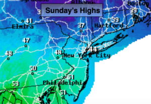
Sunny. Highs in the mid 40s. Northwest winds at 8-12mph.
Tonight:
Clear. Breezy. Lows near freezing in the City, the 20s inland. North wind less than 5mph.
Monday:
Mostly sunny. Highs in the mid 40s.
Tuesday:
Chance of rain, wet snow & sleet, especially from the City and to the South. Highs in the upper 30s to around 40º. Windy.
Wednesday:
Sun and clouds. Low potential of some snow and windier conditions. Highs in the lower 40s.
Thursday:
Partly sunny and breezy. Highs in the lower 40s.
Keep it here for a no nonsense, no hype forecast.