Synopsis:
High pressure will move off the coast Wednesday. Sun and clouds are expected with above average temperatures. The return flow around the high will bring in up mild air from the South through the end of the week. It’ll be a Spring preview around here by Thursday and Friday. Scattered showers are likely both days as weak disturbances move through. A front will slip to our South by Friday ending the well above average temperatures by next weekend.
The weekend starts off tranquil with sunshine and colder temperatures. Many of the latest computer models now have an area of low pressure developing over the Tennessee Valley later Saturday. This low strengthens some as it moves off the Delaware coast late Saturday night. Cold high pressure is slipping off the New England coast at the same time. I’ve included a low threat of snow and or rain Saturday night into early Sunday morning. Please note that this is not etched in stone and confidence at this time is low. For this to become a higher potential we’d need a few consecutive runs showing the same scenario. Whatever the case the sun will return midday Sunday.
A strong Southeast ridge will redevelop next week. This will cause readings to once again feel like Spring.
Stay tuned.
Tonight:
Mostly clear early, more clouds late. Lows in the lower to mid 30s in the City, the 20s inland. Southeast to Southwest winds at 5mph.
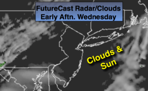
Wednesday:
Clouds and sun. Mild. Highs around 50º. Southwest winds at 5-10mph.
Thursday:
More clouds than sun. Chance of showers. Balmy. Highs in the upper 50s.
Friday:
Mostly cloudy. Chance of showers. Mild. Highs in the mid 50s. Falling temperatures are expected later in the day.
Saturday:
Sun will give way to afternoon clouds. Cold. Highs in the mid 30s.
Sunday:
Low threat of early morning snow and or rain, otherwise mostly sunny. Highs in the lower 40s.
Keep it here for a no nonsense, no hype forecast.