Synopsis:
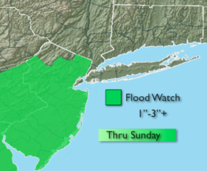
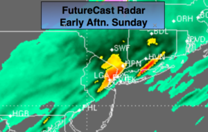
A deep plume of moisture will continue to move up the Piedmont along a stationary front today. The flow from the Gulf of Mexico and Atlantic will influence this area of rain. The rain could be heavy at times when one of the many ripples of low pressure travel along the stalled front. Total rainfall from the system of one to three inches is possible by tonight. The heavy axis of rain looks to setup along the I-95 vicinity. There will be breaks in the heavy rain. A Flood Watch has been posted for much of NJ. NYC and areas to the North and East are not included at this time in the Flood Watch. Parts of this region will most likely be included in the Watch in time. Please use caution while driving. If you see a flooded roadway- TURN AROUND, DON’T DROWN.
High pressure will move in for the beginning of the week with dry, temperate conditions.
There is no threat of snow this upcoming workweek. The pattern is garbage for snow lovers.
Stay tuned.
Today:
Periods of rain. Mild. The rain maybe heavy at times. Areas of fog. Highs in the lower to mid 50s, the 40s North and West. Northeast to South winds at 5mph.
Tonight:
Scattered showers early, otherwise remaining mostly cloudy. Lows around 40º in the City, the upper 30s inland. South to Northwest winds at 8-12mph.
Monday:
Clouds will give way to sun. Highs in the mid 40s.
Tuesday:
Mostly sunny. Highs around 40º.
Wednesday:
Partly sunny. Mild. Highs around 50º.
Thursday:
More clouds than sun. Chance of showers. Balmy. Highs in the mid 50s.
Keep it here for a no nonsense, no hype forecast.