Synopsis:
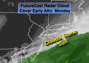
Today will be tranquil as a stalled front just offshore and a developing storm along it will keep clouds in the area. There will be some sun, especially North and West. A few of the computer models still want to graze the coastal region with a bit of rain and or snow this evening and tonight. It’ll be close but at this time I’m keeping the snow just offshore. If the band skirts the immediate coast. It won’t be a big deal.
A dynamic jet stream will move into the area Tuesday. Snow showers are in the forecast, not from the offshore low, but a trough of low pressure extending to the West of the departing storm on Tuesday. Where this trough sets up will determine who will see the snow showers from this feature. This also will not be a big deal.
Tranquil conditions are expected midweek.
Another front with a developing area of low pressure will move to the Eastern Seaboard. Rain and snow will likely develop Thursday night and then end as a possible period of snow Friday Morning. Many days to watch how this unfolds, but at this time it doesn’t look significant.
Stay tuned.
Today:
Clouds, some sun, especially inland. Highs in the lower 40s. Northeast winds at 10-2omph.
Tonight:
Mostly cloudy. A few hours of light snow is possible at the immediate coast. Lows in the upper 20s in the City, the lower to mid 20s inland. Northeast to North winds at 8-12mph.
Tuesday:
Mostly cloudy with scattered snow showers. Highs in the mid 30s.
Wednesday:
Mostly sunny and cold. Highs around freezing.
Thursday:
Sun to clouds. Highs in the lower 40s.
Friday:
Threat of morning snow. Becoming partly sunny. Highs in the mid 30s.
Keep it here for a no nonsense, no hype forecast.