Synopsis:
A storm will develop well off the Mid-Atlantic coast tonight. A few of the computer models still want to graze the coastal region with a bit of rain and or snow this evening and tonight. It’ll be close; there’s a 50/50 shot of the immediate coast getting a bit of light snow overnight. It won’t be a big deal.
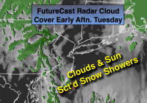
A dynamic jet stream will move into the area Tuesday. Snow showers are in the forecast, not from the offshore low, but a trough of low pressure extending to the West of the departing storm on Tuesday. There will be a mix of sun and clouds. The snow showers are likely later in the day. This also will not be a big deal.
Tranquil conditions are expected midweek.
Another front with a weak developing area of low pressure will move to the Eastern Seaboard. Rain and snow will likely develop Thursday night and then end as a possible period of snow Friday Morning. Many days to watch how this unfolds, but at this time it doesn’t look significant.
Much colder times are ahead this weekend. An area of moisture over the Southeast with an area of low pressure looks to slide just to our South later Super Bowl Sunday and Monday.
Stay tuned.
Tonight:
Mostly cloudy. A few hours of light snow is possible at the immediate coast. Lows near 30º in the City, the lower to mid 20s inland. Northeast to North winds at 8-12mph.
Tuesday:
Clouds and sun. Scattered PM snow showers. Highs in the mid 30s. North to Northwest winds at 8-12mph.
Wednesday:
Mostly sunny and cold. Highs in the mid 30s.
Thursday:
Sun to clouds. Highs in the lower 40s.
Friday:
Threat of morning snow. Becoming partly sunny. Highs in the mid 30s.
Saturday:
Sunny and cold. Highs around 30º.
Keep it here for a no nonsense, no hype forecast.