Synopsis:
It will warm up this weekend as a high pressure system moves offshore and a Southwesterly flow takes hold. Today will be the better half of the weekend with mostly sunny skies. Showers are likely Sunday morning as a weak cold front passes through but the sun should make an appearance later in the day.
Two storms will pass our latitude early next week.
Storm #1 will develop off the coast on Monday. This system should be far enough offshore to spare the area precipitation. Sun will give way to clouds.
Storm #2 will develop Monday night and Tuesday off the Mid-Atlantic coast. At the same time dynamic jet stream and upper level low will move into the area. A low threat of a period of snow is now in the forecast. The snow shield maybe close enough to graze the coast and I-95 corridor. It is not etched in stone. The shield of snow may stay just offshore, but there is enough evidence from the computer models to add a low threat of some snow Monday night. Another feature that some of the computer models are hinting at is a trough of low pressure extending to the West of the departing storm on Tuesday. Where this trough sets up will determine who will see the snow from this feature. Lots of questions to be answered.
Stay tuned.
Today:
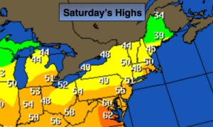
Mostly sunny, milder. Highs near 50º. Southwest winds at 10-15mph.
Tonight:
Increasing clouds. Showers developing toward midnight. Mild. Lows in 38º-45º. Southwest winds at 5-10mph.
Sunday:
Scattered morning showers otherwise becoming partly sunny during the afternoon. Mild. Highs in the lower 50s.
Monday:
Sun to clouds, cooler. Highs in the lower 40s.
Tuesday:
Mostly cloudy with a low threat of some snow. Highs around freezing.
Wednesday:
Mostly sunny and cold. Highs around freezing.
Keep it here for a no nonsense, no hype forecast.