Synopsis:
Seasonal temperatures are expected through today as cold high pressure moves over the area and off the coast. Skies will be mainly sunny.
It looks to warm up again this weekend as the high moves offshore. Saturday will be the better half of the weekend. Showers are likely Sunday with an approaching cold front.
A storm will develop off the coast on Monday. This system should be far enough offshore to spare the area precipitation.
On Tuesday, a dynamic jet stream and upper level low will move into the area. At the same time, a second area of low pressure will develop well offshore with a trough extending back to the tri-state area. A low threat of a period of snow is now in the forecast. Where this trough sets up will determine who will see the snow. Again, this is a low threat at this time with the event still a few days away.
Stay tuned.
Today:
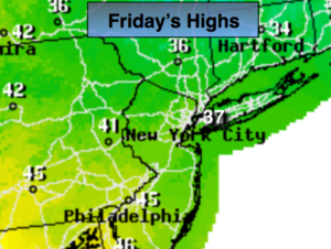
Sunny, seasonal. Highs in the upper 30s. Winds becoming Southeast at 5mph.
Tonight:
Clear, not as cold as last night. Lows in lower to mid 30s in the City, teens inland. South winds less than 5mph.
Saturday:
Mostly sunny, milder. Highs near 50º.
Sunday:
Mostly cloudy with a chance of showers. Highs in the upper 40s.
Monday:
Clouds and sun, cooler. Highs in the lower to mid 40s.
Tuesday:
Mostly cloudy with a low threat of some snow. Highs around freezing.
Keep it here for a no nonsense, no hype forecast.