Synopsis:
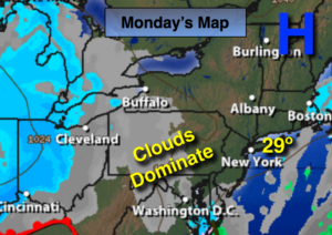
Strong high pressure over Northern New England will be responsible for the cold and tranquil conditions this Martin Luther King Jr. Day. Any sun will give way to clouds.
A weak Alberta Clipper will race through the area on Tuesday with scattered snow showers later in the day. A secondary low will form off the North Carolina coast on Tuesday night and Wednesday morning. Where this weak system tracks is still uncertain but it should be close enough for a low potential for a light accumulating snow. The possibility of a mix or even some rain exists along the coast.
Seasonally cold conditions will be with us through the end of the week.
Stay tuned.
MLK Day:
More clouds than sun. Highs in the upper 20s. Northeast 8-12mph.
Tonight:
Mostly cloudy. Lows in the mid 20s in the City, the teens inland. Northeast winds at 5mph.
Tuesday:
Mostly cloudy with a chance of snow showers later in the day. Highs in the lower to mid 30s.
Wednesday:
Mostly cloudy with a potential of accumulating snow in the morning. Some rain or a mix is possible along the coast. Highs in the lower to mid 30s.
Thursday:
Partly sunny. Highs in the mid 30s.
Friday:
Partly sunny. Highs in the upper 30s.
Keep it here for a no nonsense, no hype forecast.