Synopsis:
A significant cold front moved through early this morning. Temperatures will continue to plummet from highs near 60º just after midnight into the 30s and 20s today. Skies will be partly sunny with a brisk wind. Any standing water will freeze.
Strong high pressure will move to upstate New York through the weekend. It will be bitterly cold tonight with lows in the teens and single digits.
Martin Luther King Jr. Day on Monday will be tranquil but cold.
A weak Alberta Clipper will race through the area on Tuesday with scattered snow showers. A more significant storm may develop off the coast on Wednesday. Where this storm forms and tracks is anybody’s guess, but it does have a low potential at this time to give the area accumulating snow.
Stay tuned.
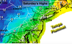
Saturday:
Partly sunny, windy and much colder. Temperatures will fall into 30s at the coast with readings falling into the 20s inland. Northwest winds at 15-25mph Wind chills will be in the teens and 20s.
Tonight:
Clear and frigid. Lows in the mid teens in the City, the single digits inland. Northwest winds at 10-20mph. Wind chills near 0º.
Sunday:
Mostly sunny, breezy and cold. Highs in the upper 20s.
Monday:
Partly sunny, breezy and cold. Highs in the upper 20s.
Tuesday:
Mostly cloudy with a chance of snow showers. Highs in the mid 30s.
Wednesday:
Mostly cloudy with a low potential of accumulating snow. Highs around 30º.
Keep it here for a no nonsense, no hype forecast.