Synopsis:
A bitter blast will be with us through the end of the year as the gates are open for Arctic air to spill into the nation as strong high pressure moves in from Canada. Readings will be below freezing through the weekend with overnight lows in the single digits and teens.
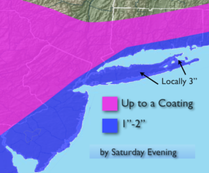
A bit of snow will fall today. A low will form well off the coast. This system in conjunction with a disturbance in the upper atmosphere will cause a few snow showers or a period of light snow. This will not be a big deal and will be a quick hitter- lasting maybe 3 to 6 hours. A dusting to 3″ is possible (highest amounts over Long Island, map above).
As stated, the bitter cold will stick around through New Year’s Day and beyond. At least it’ll be tranquil.
The weather at the stroke of Midnight New Year’s Eve will be dangerously cold. The temperature will be 11º with wind chills at 0º to -8º at Times Square.
I am keeping an eye on a Western Atlantic storm for Wednesday Night through Thursday night. The latest computer models have nudge it toward the coast. Even with this track taken verbatim the snow would miss the area. BUT, a shift more toward the coast would mean a greater potential of snow.
Stay tuned.
Today:
Mostly cloudy. A period of light snow or snow showers is likely. Highs in the mid 20s. West to Northwest winds at 5-10mph.
Tonight:
Scattered evening snow showers, otherwise partly cloudy and frigid. Lows in the mid teens in the City, the single digits inland. Northwest increasing to 10-20mph. Wind chills near 0º.
New Year’s Eve:
Mostly sunny. Frigid. Highs around 20º.
New Year’s Day:
Mostly sunny, windy and bitterly cold. Highs only in the teens. Wind Chills near 0º.
Tuesday:
Sunny and cold Highs in the lower 20s.
Wednesday:
Mostly sunny and cold Highs in the upper 20s.
Keep it here for a no nonsense, no hype forecast.