Synopsis:
A bitter blast will be with us through the end of the year as the gates are open for Arctic air to spill into the nation as strong high pressure moves in from Canada. Readings will be below freezing through the weekend with overnight lows in the single digits and teens.
The only chance of seeing any flakes the next five days will be on Saturday. A low will form well off the coast. This system in conjunction with a disturbance in the upper atmosphere will cause a few snow showers or a period of light snow. This will not be a big deal and will be a quick hitter- lasting maybe 3 to 6 hours. A dusting to 2″ is possible (highest amounts over Long Island).
As stated, the bitter cold will stick around through New Year’s Day. At least it’ll be tranquil.
The weather at the stroke of Midnight New Year’s Eve will be dangerously cold. The temperature will be 13º with wind chills at 0º to -5º.
Stay tuned.
Today:
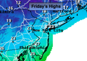
More clouds than sun. Very cold. Highs in the lower to mid 20s. Northwest winds at 8-12mph. Wind chills in the teens.
Tonight:
Partly cloudy. Frigid. Lows in the upper teens in the City, the single digits inland. Northwest winds 5mph.
Saturday:
Mostly cloudy. A period of light snow or snow showers is likely for a few hours. Highs in the mid 20s.
New Year’s Eve:
Mostly sunny. Frigid. Highs around 20º.
New Year’s Day:
Mostly sunny, windy and bitterly cold. Highs only in the teens.
Tuesday:
Sunny and cold Highs in the lower 20s.
Keep it here for a no nonsense, no hype forecast.