Synopsis:
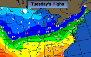
Much colder times are on the this week as the gates are open for Arctic air to spill into the nation. The map above depicts the highs for the nation on Tuesday. Readings will be below freezing through Friday with overnight lows in the single digits and teens. There has been chatter about a storm for late week or this weekend. The models are still all over the place as to placement and timing. A storm mostly likely will be on the map. Where it sets up and goes from there is anybody’s guess. Right now, I’m including a potential of light snow for Saturday as it may form close enough for some snow. Again, this is not etched in stone.
Stay tuned.
Merry Christmas!
Tonight:
Clear to partly cloudy. Very cold. Lows in the lower 20s in the City, then teens inland. Diminishing West wind at 10-20mph.
Tuesday:
Mostly sunny. Cold. Highs around 30º. West winds at 10-15mph.
Wednesday:
Mostly sunny. Very cold. Highs in the mid 20s.
Thursday:
Mostly sunny. Very cold. Highs in the lower to mid 20s.
Friday:
Mostly sunny. Very cold. Highs in the mid 20s.
Saturday:
Mostly cloudy. A chance of light snow. Highs in the mid 20s.
Keep it here for a no nonsense, no hype forecast.