Synopsis:
Areas North and West of the City are experiencing a white Christmas. A dusting to 3″ of snow was reported in spots. Elsewhere, we’ll have to wait at least another year. The low that was responsible for the precipitation is bombing off the New England coast. The result will be very strong winds out of the West gusting up to 50mph today. Temperatures will remain steady in the 30s under mostly sunny skies.
Much colder times are on the this week as the gates are open for Arctic air to spill into the nation. Readings will be below freezing through Friday with overnight lows in the single digits and teens.There has been chatter about a storm for late week or this weekend. The models are still all over the place as to placement and timing. A storm mostly likely will be on the map. Where it sets up and goes from there is anybody’s guess.
Stay tuned.
Merry Christmas!
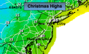
Christmas Day:
Early morning snow or rain North and East of the City, otherwise mostly sunny, windy and colder. West winds at 15-30mph with gusts 40-50mph. Highs in the mid to upper 30s.
Tonight:
Clear to partly cloudy. Very cold. Lows in the lower 20s in the City, then teens inland. Diminishing West wind at 10-20mph.
Tuesday:
Mostly sunny. Cold. Highs around 30º.
Wednesday:
Mostly sunny. Very cold. Highs in the mid 20s.
Thursday:
Mostly sunny. Very cold. Highs in the mid 20s.
Friday:
Partly sunny. Very cold. Highs in the mid 20s.
Keep it here for a no nonsense, no hype forecast.