Synopsis:
A cool down will occur today and Thursday as high pressure ridges in from Southern Canada. Today is the last day of Fall and it’ll be tranquil. Winter arrives Thursday at 11:28AM. The change of season will be fairly uneventful.
Looking down the pike. Temperatures will be above average Friday into the weekend. In fact, Saturday’s highs will feel more like Spring. Highs will approach 60º with showers.
After this time frame it does get interesting. The jet stream will be active and there is a decent amount of cold air just to our North for Christmas Day. There has been mayhem with the models on whether it’ll be a balmy Christmas or one that could be cold and possibly white. As of this writing, and looking at the latest computer guidance, it looks like the cold front will move through the area. An area of low pressure may develop close enough to give the region some precipitation. Will it be cold enough for snow? Will there be enough precipitation or will the storm form to far North and East to be a big player. How will it all play out?
Stay tuned.
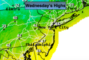
Today:
Partly sunny, breezy and cooler. Highs in the lower to mid 40s. Northwest winds at 10-20mph.
Tonight:
Clear to partly cloudy. Lows in the 20s throughout. Northwest winds at 5-10mph.
Thursday:
Mostly sunny and chilly. Highs in the upper 30s.
Friday:
Mostly cloudy. Milder. A few showers possibly mixed with snow well inland. Highs in the 40s.
Saturday:
Clouds with some peeks of sun. Balmy. Highs around 60º.
Sunday:
Sun and clouds. Cooler. Highs in the mid 40s.
Keep it here for a no nonsense, no hype forecast.