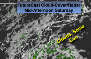
Synopsis:
The weekend looks to be much warmer than recent days as a Southwesterly flow takes hold. It won’t be a brilliantly sunny weekend though, at least for today. A weak disturbance riding along the periphery of an area of high pressure over the Western Atlantic will provide plenty of clouds today. A bit of light rain or drizzle is possible this morning. It will not be a washout. The sun should make an appearance at times during the afternoon.
By Sunday, a stronger Southwest flow will develop pushing temperatures some fifteen degrees above average. Morning fog and spotty drizzle will give way to partly sunny warm conditions. The average high for this time of the year is 65º.
A cold front will move in Sunday Night with a shower. The beginning of the workweek looks pleasant with a true taste of Fall arriving.
Stay tuned.
Today:
Mostly cloudy and mild with spotty showers or areas of drizzle mainly in the morning. Highs in the lower 70s. Northeast winds at 5mph.
Tonight:
Cloudy with areas of drizzle and fog. Mild. Lows in the mid 60s in the City, the upper 50s inland. Southeast to South winds less than 5mph.
Sunday:
Morning clouds, drizzle and fog will give way to sun. Warm. Highs near 80º.
Monday:
Partly sunny and much cooler. Highs in the lower to mid 60s.
Tuesday:
Mostly sunny and cool. Highs around 60º.
Wednesday:
Sunny. A top ten day. Highs around 70º.
Keep it here for a no nonsense, no hype forecast.