Synopsis:
A high pressure system over Eastern Canada will continue to supply cooler and more seasonal readings for mid-October through today. Any sunshine will give way to clouds later in the day.
The seasonal readings won’t last too long as the upcoming weekend looks to be much warmer as a Southwesterly flow takes hold once again. It won’t be a brilliantly sunny weekend though. A weak disturbance will provide plenty of clouds Saturday. A bit of light rain or drizzle is possible both Saturday and Sunday morning. It will not be a washout. The sun should make an appearance both afternoons.
A cold front will move in Sunday Night with a shower. The beginning of the workweek looks pleasant with typical readings for this time of the year.
Stay tuned.
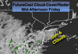
Today:
Sun will give way to clouds. Highs in the mid 60s. East winds at 8-12mph.
Tonight:
Cloudy with areas of drizzle and fog. Lows around 60º in the City, the 50s inland. East wind at 5mph.
Saturday:
Mostly cloudy and mild with spotty showers or areas of drizzle. Highs in the lower to mid 70s.
Sunday:
Clouds and sun. Spotty morning drizzle. Warm. Highs near 80º.
Monday:
Partly sunny and much cooler. Highs in the mid 60s.
Tuesday:
Mostly sunny and cool. Highs in the lower 60s.
Keep it here for a no nonsense, no hype forecast.