Synopsis:
Summer wants to stick around through the weekend. There will be clouds and some sun. Another round of scattered showers and storms are possible late in the day and evening today as a weak upper level unit of energy works through. It’ll be warm and humid.
High pressure will build in for the last weekend of the Summer. A mix of clouds and sun are expected with warm, humid conditions.
Tropical Storm Jose is between Bermuda and the Bahamas. The storm has begun a West to Northwest movement and will become a hurricane soon. Will it eventually affect the East coast? Some of the models have a cutoff low grabbing the storm and stalling off the Mid-Atlantic, others bring it harmlessly out to sea. The models have to sort through the mayhem. This is still a couple of days from becoming a clear situation. The chances are slim for Jose to directly affect our area at this time.
Stay Tuned.
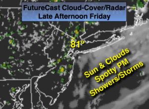
Today:
Partly sunny, warm and humid. Highs in the lower 80s. Winds becoming Southeast at 5-10mph.
Tonight:
Partly cloudy with a spotty evening shower or storm. Lows in the upper 60s in the City, near 60º inland. Southeast to Northeast winds at 5mph.
Saturday:
Partly sunny. Highs around 80º.
Sunday:
Partly sunny. Highs around 80º.
Monday:
Partly sunny. Highs around in the upper 70s.
Tuesday:
Partly sunny, breezy. Highs around in the mid 70s.
Keep it here for a no nonsense, no hype forecast.