Synopsis:
Irma’s remnants will affect out weather through tonight. There will be clouds and some sun. Another round of scattered showers and storms are possible late in the day and this evening. It will be warm and a bit more humid with readings near 80º
High pressure will build in Friday and into the last weekend of the Summer. A mix of clouds and sun are expected with warm readings.
Hurricane Jose is meandering in the Atlantic between Bermuda and the Bahamas. The storm is under very weak steering currents which will result in Jose being around for a while well off the Atlantic coast. Will it eventually affect the East coast? Some of the models have a cutoff low grabbing the storm and stalling off the Mid-Atlantic. The models have to sort through the mayhem. This is still several days from becoming a clear situation. The chances are slim for Jose to affect our area at this time.
Stay Tuned.
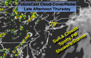
Today:
Sun and clouds. Warm. Late day and evening spotty shower and storms. Highs in the upper 70s. Southwest to South winds at 5-10mph.
Tonight:
Mostly cloudy with a spotty evening shower or storm. Lows in the upper 60s in the City, near 60º inland. Southwest winds at 5mph.
Friday:
Partly sunny and warm. Highs in the lower 80s.
Saturday:
Partly sunny. Highs around 80º.
Sunday:
Partly sunny. Highs around 80º.
Monday:
Partly sunny. Highs around in the upper 70s.
Keep it here for a no nonsense, no hype forecast.