Synopsis:
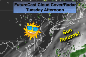
An area of high pressure will move into the region today and dominate our weather into Friday. The sun will return later this morning into the afternoon and it will become a gorgeous day. Temperatures and humidity levels will be in check through the end of the week. A string of beauties are on the way.
By later Friday and into the weekend a Southerly flow will develop. This will increase the humidity and the threat of scattered showers and storms. It won’t be a washout, but it also won’t be as stellar as our midweek weather.
Stay Tuned.
Today:
Clouds to sun. Highs around 80º. Northwest winds at 5-10mph.
Tonight:
Clear and comfortable cool. Lows in the mid 60s in the City, the 50s inland. Northwest winds at 5mph.
Wednesday:
Sunny. A top ten day. Highs in the lower 80s.
Thursday:
Mostly sunny. Highs in the lower 80s.
Friday:
Sun and clouds. A stray afternoon shower is possible. Highs around 80º.
Saturday:
More clouds than sun. Scattered showers and storms. It will not be a washout. Highs in the upper 70s.
Keep it here for a no nonsense, no hype forecast.