Synopsis:
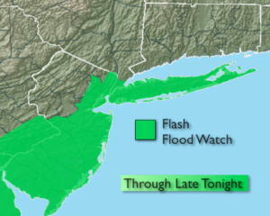
An area of low pressure will move into the area from Northern Virginia today and tonight. Showers and thunderstorms are expected. Some of the rain maybe torrential at times, especially later in the day and early tonight. 1″-2″+ of rain may fall by the late tonight. A Flash Flood Watch is in effect for the NYC vicinity and Central and Southern NJ. If you encounter a flooded roadway-TURN AROUND, DON’T DROWN.
The rain will taper off later tonight.
The sun will return Tuesday and a string of beautiful days will be with us into Friday as high pressure dominates our area.
Stay Tuned.
Today:
Periods of rain. The rain may be heavy at times in the afternoon, especially closer to the coast. Unseasonably cool. Highs around 70º. Southeast winds at 5-10mph.
Tonight:
Rain and possibly early thunderstorms. The rain maybe heavy at times early, especially closer to the coast. Lows in the 60s. Northeast to Northwest winds at 8-12mph.
Tuesday:
Becoming partly sunny. Highs in the lower 80s.
Wednesday:
Sunny with low humidity. A top ten day. Highs in the lower 80s.
Thursday:
Mostly sunny. Highs in the lower 80s.
Friday:
Sun and clouds. Spotty PM storms. Highs around 80º.
Keep it here for a no nonsense, no hype forecast.