
Synopsis:
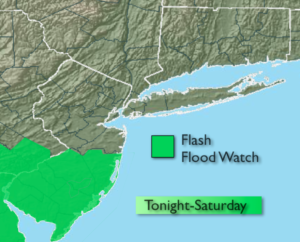
Morning fog in spots will give way to a mix of sun and clouds. A stray afternoon storm can’t be ruled out. The developing Low pressure over Northern Virginia will move East and off the Delaware coast on Saturday. The computer models have been all over the place with the speed and placement of the axis of heavy rain. It now looks like the heaviest rain will fall farther South and the system will move quicker meaning many areas will NOT get into the heavy rain band. This is why a Flash Flood Watch is only up for Southern NJ-1″-3″ may fall in this area. Many regions North of the City may not see much in the way of rainfall . The timing of the rain looks to be around midnight through early Saturday, again mainly South of the City. In fact, the sun may make an appearance later in the day Saturday.
Sunday will be the better half of the weekend with plenty of sunshine and low levels of humidity.
Stay tuned.
Today:
Clouds and sun. Humid. A stray storm is possible in the afternoon, especially South and West of the City. Highs in the lower 80s. Northeast to East winds at 5-10mph.
Tonight:
Cloudy with rain and possibly a thunderstorm, mainly from the City on South. Lows in the 60s throughout. Northeast winds increasing to 10-20mph late.
Saturday:
On and off rain South of the City during the morning. Becoming partly sunny during the afternoon, especially inland and North. Breezy. Highs in the 70s.
Sunday:
Partly sunny. Highs around 80º.
Monday:
Partly sunny. Highs in the upper 70s.
Tuesday:
Partly sunny and warmer. Highs in the mid 80s.
Keep it here for a no nonsense, no hype forecast.