Synopsis:
Wednesday will feature the return of the sun after morning clouds burn off as high pressure moves in. The humidity will be low and temperatures will still be several degrees below the average high of 84º.
Warmer and more humid conditions will return by weeks end with a scattered storm threat late Thursday into Friday. Low pressure moving out of the Ohio Valley may give parts of the area another round of heavy rain. Where the heavy rain falls is not etched in stone as the models are in disagreement.
The weekend at this point looks decent as long as the low doesn’t slow down. There are indications that Saturday morning may feature some rain.
Stay tuned.
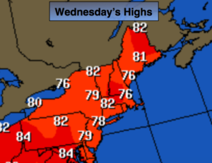
Today:
Becoming mostly sunny and pleasant. Highs in the upper 70s. Winds becoming Southeast at 5-10mph.
Tonight:
Partly cloudy. Lows in the 60s throughout. South to Southwest winds at 5mph.
Thursday:
More clouds than sun.. A stray storm is possible later in the afternoon. Highs in the lower 80s.
Friday:
Mostly cloudy and humid with scattered showers and storms. The rain maybe heavy at times later in the day and at night. Highs around 80º.
Saturday:
Threat of morning rain otherwise, partly sunny. Highs around 80º.
Sunday:
Partly sunny. Highs in the lower 80s.
Keep it here for a no nonsense, no hype forecast.