Synopsis:
The heat and humidity will be high into the beginning of the holiday weekend as a Bermuda high sets up shop off the Southeast coast. June’s finale will be uncomfortable. Our first chance of a stray storm will come this afternoon or evening.
Looking at the long holiday weekend- the weather looks typical for July with warm readings and a chance of afternoon scattered storms Saturday and then again Sunday morning with a weak front moving through. It will not be a washout. Monday and July 4th looks mainly sunny and warm with lower humidity.
Stay tuned.
Today:.
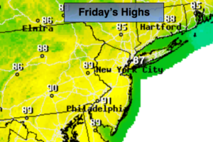
Hazy, very warm and humid. A stray afternoon/evening storm is possible. Highs in the upper 80s. Southwest winds at 15-25mph.
Tonight:
An evening shower or storm otherwise, partly cloudy, warm and muggy. Lows in the mid 70s in the City, the 60’s to around 70º inland. Southwest winds at 8-12mph.
Saturday:
Hazy, very warm and humid. Spotty afternoon/evening storms are possible. Highs near 86º-90º.
Sunday:
Spotty morning storms, otherwise mostly sunny. Highs in the mid to upper 80s.
Monday:
Partly sunny. Less humid Highs in the mid to upper 80s.
July 4th (Tuesday):
Partly sunny. Highs in the mid 80s.
Keep it here for a no nonsense, no hype forecast.