Synopsis:
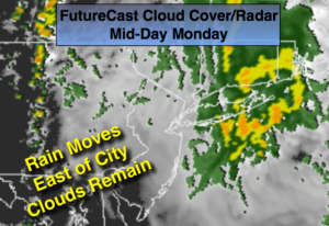
I guess 2 out of 3 ain’t bad for the Memorial Holiday Weekend. Showers are in the forecast for the holiday. The big question is how fast does the front move offshore. Does the shower threat end by late morning or does the threat continue into mid-afternoon? Right now, the latest computer guidance suggests showers will work into the area by late evening (later farther East). A few thunderstorms are possible. Showers will continue in the morning. The thinking is the rain will push East of the City during the mid-day hours (FutureCast Cloud/Cover Radar above). Clouds will hang tough and it will be very cool.
A grey start to the shorten workweek is expected Tuesday.
The sun will return with mild readings midweek.
Stay tuned.
Tonight:
Mostly cloudy. Showers and thunderstorms developing later this evening South and West and by Midnight from the City on East. Lows 55º-60º. Southeast to East winds at 8-12mph.
Memorial Day:
Cloudy with scattered showers and possibly a thunderstorm. There will be improving conditions from mid-day on from West to East. Highs in the mid 60s. Northeast winds at 10-15mph.
Tuesday:
Mostly cloudy. A spot late day storm is possible. Highs around 70º.
Wednesday:
Partly sunny. Highs in the upper 70s.
Thursday:
Mostly sunny. Highs in the mid 70s.
Friday:
Partly sunny and warm. A spotty late day storm is possible. Highs near 80º.
Keep it here for a no nonsense, no hype forecast.