Synopsis:
It’s the same song and dance as we continue through the Memorial Day Weekend as weak disturbances will keep a mix of clouds and sun in the forecast. The next chance of showers and thunderstorms will be tonight into a part of Memorial Day. There will be dry times, especially tomorrow afternoon. The big question is how fast does the front move offshore. Does the shower threat end by late morning or does the threat continue into mid-afternoon?
Stay tuned.
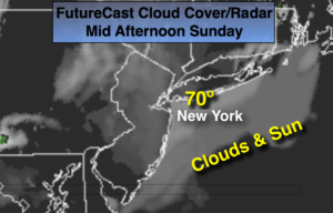
Today:
Clouds and sun. Highs around 70º. Southeast wind at 8-12mph.
Tonight:
Mostly cloudy. Showers and thunderstorms developing after midnight. Lows 55º-60º. Southeast to East winds at 5-10mph.
Memorial Day:
Mostly cloudy with scattered showers and possibly a thunderstorm. There will be improving conditions from mid-day on from West to East. Highs in the mid 60s.
Tuesday:
Partly sunny Warmer. Highs in the mid to upper 70s.
Wednesday:
Partly sunny. Highs in the upper 70s.
Thursday:
Partly sunny. Highs in the mid 70s.
Keep it here for a no nonsense, no hype forecast.