Synopsis:
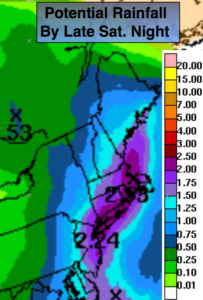
A storm will ride up the coast this weekend. Today will feature the steady and possibly heavy rain. The best chance of heavy rain is along the I-95 corridor and to the coast. One to two and a half inches of rain is likely. The rain will taper off later this evening to the West and end over Eastern areas by early Sunday morning.
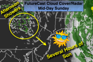
Mother’s Day Sunday continues to look optimistic as the storm will continue to move Northeast. This will result in morning clouds and possibly some showers well east to give way to several hours of sun and clouds. An upper level disturbance will swing through later in the afternoon on Mother’s Day with scattered showers (FutureCast Cloud Cover/Radar above). To reiterate, the day will not be a washout and the sun will shine for a time! Whew.
Much warmer times are in our future as we head into next week with readings getting well into the 80s.
Stay tuned.
Today:
Rain. Local downpours. very cool. Highs 49º-55º. Northeast wind at 15-25mph with higher gusts at the coast.
Tonight:
Rain taper off from West to East. Windy. Lows in the 40s. Northeast to Northwest winds at 1-25mph with gusts over 30mph.
Mother’s Day (Sunday):
Morning clouds with a few showers East of the City, otherwise becoming partly sunny for several hours. A few showers are possible during the afternoon. Highs in the mid 60s..
Monday:
Partly sunny. Highs in the mid to upper 60s.
Tuesday:
Mostly sunny, milder. Highs in the mid 70s.
Wednesday:
Mostly sunny, warm. Highs in the mid 80s.
Keep it here for a no nonsense, no hype forecast.