Synopsis:
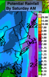
A storm will move up the Appalachians today. Scattered areas of rain early this morning will become steadier and heavy by mid to late morning. The rain will be heavy at times through early afternoon. One to two inches of rain is possible by Saturday morning (map above). Flooding of streets are likely in flood prone areas. The rain will taper off from West to East this afternoon but showers will continue into tonight.
The storm will slow down over Northern New England over the weekend and keep the threat of showers in the forecast. It will not be a washout. Saturday may feature a few hours of sun during the morning but another round of showers is likely in the afternoon and evening. Clouds will dominate on Sunday with spotty showers and cooler temperatures. Stay tuned.
Today:
Areas of rain early this morning becoming steadier and heavier by mid to late morning. Heavy rain is likely through early afternoon. The rain may quit for several hours later in the day. Highs in the lower 60s. Windy for the first part of the day. East winds at 15-30mph with higher gusts at the coast. The winds will diminish later in the afternoon.
Tonight:
Showers. Lows in the 50s. Southeast to South wind at 8-12mph.
Saturday:
Some morning sun. Scattered afternoon showers. Highs in the mid 60s.
Sunday:
Mostly cloudy with spotty showers, very cool. Highs around 60º.
Monday:
Clouds and sun, a stray shower is possible, chilly. Highs in the mid 50s.
Tuesday:
Partly sunny. Highs in the upper 50s. Highs in the upper 50s.
Keep it here for a no nonsense, no hype forecast.