Synopsis:
The storm responsible for the deluge Friday will continue to move into Upstate NY tonight. Many areas in around the City reported between 2″-4″ of rain which caused flooding earlier Friday. Scattered showers are expected overnight as the complex system moves nearby.
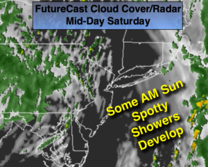
The storm will slow down over Northern New England over the weekend and keep the threat of showers in the forecast. It will not be a washout. Saturday may feature a few hours of sun during the morning but another round of showers is likely in the afternoon and evening (FutureCast Cloud Cover/Radar above). Clouds will dominate on Sunday with spotty showers and cooler temperatures. Stay tuned.
Rest of Today:
Heavy rain will push North and East of the City and taper off there by late afternoon. Scattered showers are likely into the evening throughout the region. Gusty winds East of the City will diminish.
Tonight:
Scattered showers. Lows in the 50s. Southeast to South wind at 8-12mph.
Saturday:
Some morning sun. Scattered afternoon showers. Highs in the mid 60s. South wind at 10-20mph.
Sunday:
Mostly cloudy with spotty showers, very cool. Highs around 60º.
Monday:
Clouds and sun. Astray shower is possible, chilly. Highs in the mid 50s.
Tuesday:
Mostly cloudy. Highs in the mid to upper 50s.
Wednesday:
Mostly cloudy. Highs in the upper 50s.
Keep it here for a no nonsense, no hype forecast.