Synopsis:
Clouds and areas of fog early this morning will give way to mainly sunny skies. Temperatures will reach June-like levels both today and Saturday. It’ll be significantly cooler along the coast with the wind blowing off the colder Atlantic in spots.
On Saturday a few stray showers are possible in the morning (most areas will be dry) otherwise the sun will dominate the rest of the day. Cooler air will return for Sunday as a backdoor cool front moves through. A mix of sun and clouds is expected.
Stay tuned.
Today:
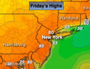
Clouds will give way to partly sunny skies. Warm. Highs around 80º. Much cooler at the coast and over Long Island. West to Southwest wind at 5-10mph.
Tonight:
Becoming mostly cloudy with a few showers late. Mild. Lows in the lower to mid 60s in the City, the upper 50s inland. Light Southeast wind.
Saturday:
Summer-like. Stray morning shower otherwise partly sunny. A spotty late day storm can’t be ruled out. Highs 80º-85º.
Sunday:
Partly sunny. Not as warm. Highs in the mid 60s.
Monday:
Partly sunny. Warmer. Highs in the mid to upper 70s.
Tuesday:
Partly sunny. mild. Highs in the lower 70s.
Keep it here for a no nonsense, no hype forecast.