Synopsis:
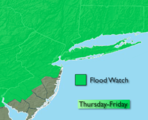
An area of heavy rain and thunderstorms will move through most of the region late this afternoon and into the early evening. An additional inch of rain is possible in a short period of time. Use caution on roadways as flooding will occur in areas of heavy rain. A Flood Watch is up for much of the area into late tonight/early Friday morning for the possibility of some streams, creeks and main stem river to overflow their banks. The storm will slowly pull away Friday and allow for improving conditions for the weekend.
Spring’s nice side will be with us Sunday through Tuesday as temperatures warm nicely and the sun dominates. It’ll feel like mid-June by next week.
Stay Tuned.
Into This Evening:
Periods of rain, possibly heavy at times. Scattered thunderstorms.
Tonight:
Any showers will end early. Remaining mostly cloudy. Lows in the 40s. Southwest wind at 10-20mph.
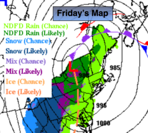
Friday:
Mostly cloudy, windy and cool with spotty showers. Highs in the lower 50s. Southwest to Northwest wind at 15-30mph.
Saturday:
Sun and clouds. Highs in the lower to mid 50s.
Sunday:
Mostly sunny and mild. Highs in the mid 60s.
Monday:
Mostly sunny and warmer. Highs in the mid 70s.
Tuesday:
Mostly sunny and warm. Highs around 80º.
Keep it here for a no nonsense, no hype forecast.