Synopsis:
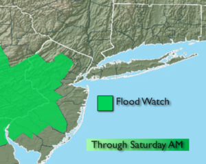
The storm responsible for the heavy rain event will move over the region tonight and off the coast Saturday. Periods of rain is expected overnight. The rain will be heavy at times early. A Flash Flood Watch is up for Western NJ for the possibility of stream and creeks rising above their banks. Street and highway flooding is possible throughout the region in times of heavy rain.
The rain will taper off Saturday morning. It could end as a bit of mixed precipitation especially North. By this time, possible total rain amounts could reach 1″-3″. The sun could make an appearance later in the day. Sunday will be the better half of the weekend with plenty of sunshine and seasonal readings.
The pattern is very active and another storm will approach the area Tuesday.
Stay Tuned.
Tonight:
Periods of rain, heavy at times early. Lows in the 30’s throughout. Northeast wind will become North late at 15-25mph.
Saturday:
Rain likely during the morning. A mix is possible at times well North. The sun may return return by late day. Highs in the upper 40s. North wind at 15-25mph.
Sunday:
Mostly sunny. Highs in the mid to upper 50s.
Monday:
Partly sunny. Highs in the mid 50s.
Tuesday:
Rain likely. Highs in the lower to mid 50s.
Wednesday:
Partly sunny. Highs around 60º.
Stay Tuned.
Keep it here for a no nonsense, no hype forecast.