Synopsis:
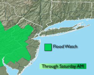
A significant rain event is underway as low pressure from the midwest moves over the tri-state area today through Saturday morning. The potential is there for a mix well to the North at times during this event. Just enough cold air will be present to cause light accumulations of sleet, freezing rain and possibly some snow over parts of the Poconos, Catskills and Interior CT. There will be dry times this morning. The rain will become steadier and heavier later today and tonight as the storm strengthens. A flood watch is up for parts of New Jersey through Saturday Morning.
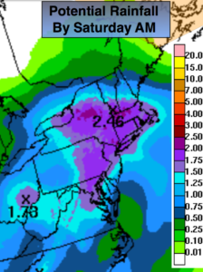
The rain will taper off Saturday morning. By this time, possible total rain amounts could reach 1″-3″ (map above). The sun could make an appearance later in the day. Sunday will be the better half of the weekend with plenty of sunshine and seasonal readings.
The pattern is very active and another storm will approach the area Tuesday.
Stay Tuned.
Today:
Cloudy with periods of rain. There will be dry times. The rain will be heavy at times later in the day. A mix is possible over the higher elevations to the North of the City. Highs in the 40s, 30s inland. East wind increasing to 15-25mph with higher gusts late by the coast.
Tonight:
Rain, heavy at times. A mix is possible at times well North. Lows in the 30’s throughout. Northeast wind at 15-25mph.
Saturday:
Rain likely during the morning. The sun may return return by late day. Highs in the upper 40s.
Sunday:
Mostly sunny. Highs in the mid 50s.
Monday:
Partly sunny. Highs in the mid 50s.
Tuesday:
Rain likely. Highs in the lower 50s.
Stay Tuned.
Keep it here for a no nonsense, no hype forecast.