Synopsis:
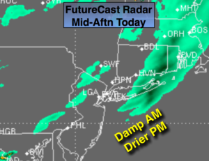
Unsettled times will be with us today and tomorrow with a series of low pressure systems affecting the tri-state area. One disturbance will move through with periods of rain through mid-day today and areas of fog. Much of the rain will move off the coast by mid-afternoon so the PM commute will be better than the AM commute (FutureCast Radar above).
Another round of rain is likely for Tuesday with system number two. At least it won’t be as raw with temperatures flirting with 60º.
It’ll finally dry out by Wednesday.
Stay Tuned.
Today:
Cloudy with on and off light rain and drizzle. It should be drier by mid-afternoon but skies will remain grey. Milder. Highs in the mid 50s. Southeast to Southwest winds at 5mph.
Tonight:
Cloudy with areas of light rain and drizzle. Patchy fog. Milder than recent nights. Lows in the 40s to lower 50s. South to Northeast wind at 5mph.
Tuesday:
Scattered showers. Warm. Highs around 60º.
Wednesday:
The sun returns. Highs in the upper 50s.
Thursday:
Mostly sunny. Highs in the mid 50s.
Friday:
Thickening clouds with rain developing. Highs in the lower 50s.
Stay Tuned.
Keep it here for a no nonsense, no hype forecast.