Synopsis:.
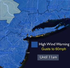
Strong winds will be with us for today behind a cold front. A High Wind Warning has been posted for gusts up to 60mph this morning. The winds will diminish some this afternoon as a strong storm moves from Northern Maine into Southeastern Canada. It’ll be much cooler today under a mix of sun and clouds.
Much colder temperatures are expected by Friday and Saturday as a cold pool of air moves in from Canada. A few scattered snow showers are possible later Friday with a weak disturbance moving through. By Sunday temperatures will be near seasonal averages with high pressure overhead. Warmer readings will be on the way for the beginning of next week.
Today:
Partly sunny, windy and much cooler. Highs in the upper 40s. West to Northwest winds at 15-30mph with gusts to 60mph this morning. The winds will abate some this afternoon with gusts to 40mph.
Tonight:
Mostly clear and much colder than recent nights. Lows around 30º in the City, the 20’s inland. West wind at 5-10mph.
Friday:
Sun will give way to clouds. Late day flurries or snow showers are possible (this isn’t a big deal). Highs around 40º.
Saturday:
Partly sunny and cold. Highs in the mid 30s.
Sunday:
Partly sunny, seasonal. Highs in the mid 40s.
Monday:
Partly sunny. Mild once again. Highs in the mid 50s.
Stay Tuned.
Keep it here for a no nonsense, no hype forecast.