Synopsis:.
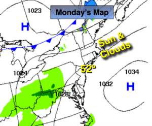
As we flip the calendar from February to March this week our temperatures will once again feel more like Spring than Winter. High pressure will move off the coast today. The return flow will bring up mild air from the South. Temperatures will once again rise in steps to well above average readings.
On and off showers will accompany a warm front on Tuesday and an approaching cold front on Wednesday. Thunderstorms are possible later Wednesday as the front nears.
Looking ahead, much colder temperatures are expected by Friday and Saturday. A few scattered rain or snow showers are possible on Friday with a weak low passing through. No major storms are in sight between day 5 and day 7.
Today:
Morning sun will give way to afternoon clouds. Mild again. Highs in the lower 50s. Southwest winds at 8-12mph.
Tonight:
Mostly cloudy and not as chilly as last night. Lows in the mid 40s in the City, the 30s inland. Southwest to East wind at 5mph.
Tuesday:
Clouds and sun. Much warmer. Showers are possible mainly in the afternoon. Highs around 60º.
Wednesday:
Mostly cloudy. May-like. Highs in the 60s to around 70º. Scattered showers and thunderstorms are likely.
Thursday:
Partly sunny, breezy and much cooler. Highs in the upper 40s.
Friday:
Mostly cloudy and chilly with a chance of rain and or snow showers. Highs in the lower 40s.
Stay Tuned.
Keep it here for a no nonsense, no hype forecast.