Synopsis:.
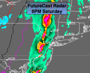
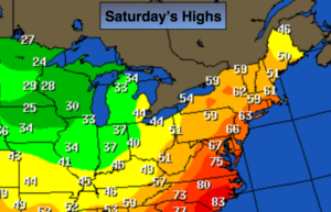
Our Spring preview will continue for one more day. A cold front will approach the region today (2nd map above shows the sharp contrast in temperatures). Ahead of the front, a balmy, moist flow will engulf the region. There will be areas of drizzle during the morning hours. Several hours of sunshine is possible for areas mainly away from the coast during the day. North and East of the City the clouds will remain stubborn keeping the mercury in the 50s. The cold front will move in toward sunset with a line of showers and possible thunderstorms (1st map above).
Colder temperatures will make a comeback by Sunday.
Looking ahead no major cold blasts or storms are in sight as we flip the calendar from February to March. In fact, mild readings will return.
Today:
Mostly cloudy and balmy with areas of drizzle and patchy fog in the morning. Becoming partly sunny for a time. A line of showers and possible thunderstorms will move in toward sunset. Highs in the 60s to around 70º from the City on West, the 50s to the East. Southeast wind at 10-20mph with higher gusts.
Tonight:
Evening showers and possible thunderstorms otherwise, becoming mostly clear and much colder. Breezy. Lows in the 30s throughout. West wind at 15-25mph with higher gusts.
Sunday:
Partly sunny, breezy and colder with readings in the mid 40s.
Monday:
Partly sunny. Highs around 50º.
Tuesday:
Mostly cloudy and mild with scattered showers. Highs in the mid 50s.
Wednesday:
Mostly cloudy and mild with scattered showers. Highs in the mid 50s.
Stay Tuned.
Keep it here for a no nonsense, no hype forecast.