Synopsis:.
The Spring Preview continues. The only exception will be those coastal areas that remain socked in with low clouds and fog with a cooler wind off the Atlantic. A southwest wind will prevail boosting the mercury some twenty degrees above average though Saturday with high pressure off the Southeast coast pumping up the warmth. A cold front will approach on Saturday with periods of rain-most likely in the afternoon.
Colder temperatures will make a comeback by Sunday.
Looking ahead no major cold blasts or storms are in sight as we flip the calendar from February to March.
Today:
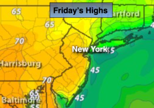
Areas of morning fog, otherwise partly sunny, continued warm. Highs in the upper 60s to lower 70s inland, the 50s and 60s at the coast and North and East of the City. South wind at 8-12mph.
Tonight:
Mostly cloudy with areas of fog and scattered drizzle. Lows in the 50s throughout. South to Southeast wind less than 5mph.
Saturday:
Mostly cloudy and balmy with areas of drizzle and scattered showers. A line of heavy showers and possible thunderstorms will move in toward sunset. Highs in the 60s West of the City, the 40s and 50s to the East.
Sunday:
Partly sunny, windy and colder with readings in the mid 40s. The normal high is 45º.
Monday:
Partly sunny. Highs in the upper 40s.
Tuesday:
Mostly cloudy and mild with scattered showers. Highs in the mid 50s.
Stay Tuned.
Keep it here for a no nonsense, no hype forecast.