Synopsis:.
Clouds will dominate today as the atmosphere is moisture laden. There will be areas of dense fog through this morning. Temperatures will remain well above average. Spotty light rain is possible just about anytime.
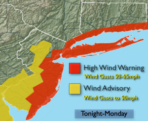
The storm over the South will become a Nor’easter for our area as it rides along the coast Monday and into a part of Tuesday and intensifies. Heavy rains and highs winds are likely. The pattern is garbage for any snow to fall in our area, key factors are missing. There is a slight chance of wet snow or sleet well inland over the higher elevations on Monday (this is said with low confidence). Wind gusts up to 65mph are possible Monday along the coast. A High Wind Warning is in effect for the entire coast and all of New York City for Monday. One to three inches of rain is possible. Coastal flooding is possible at the times of high tide. The storm will pull away Monday night and Tuesday with on and off rain expected.
A more Winter-like pattern looks to be in the cards for the end of January and into February. Stay Tuned.
Today:
Cloudy. Areas of fog. Spotty Light rain. Highs in the mid to upper 40s. East Northeast winds at 5-10mph.
Tonight:
Cloudy. Spotty light Rain. Lows around 40º in the City, the 30s inland. Northeast winds increasing to 15-25mph.
Monday:
Spotty light rain in the morning, otherwise rain, heavy at times later in the day. Windy. East winds could gust up to 65mph along the coast. Highs in the mid 40s.
Tuesday:
Scattered areas of rain. Highs in the mid 40s.
Wednesday:
Partly sunny and mild. Highs around 50º.
Thursday:
Partly sunny and mild. Highs in the upper 40s.
Stay Tuned.
Keep it here for a no nonsense, no hype forecast.