Synopsis:.
The storm over the South will become a Nor’easter for our area as it rides along the coast and intensifies Monday. It’ll become breezy later tonight with spotty showers.
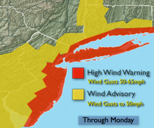
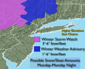
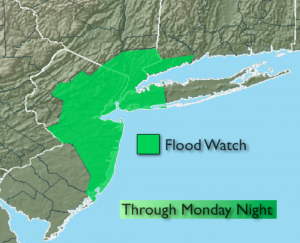
Areas of rain is expected for the morning commute with increasing Northeast winds. The brunt of the storm will be Mid-day into the evening on Monday. Wind gusts up to 65mph are possible along the coast. A High Wind Warning is in effect for the entire coast and all of New York City for Monday. One to three inches of rain is possible. A Flash Flood Watch is up for most of the tri-state area. Coastal flooding is possible at the times of high tide. The pattern is garbage for any snow to fall in the immediate area, key factors are missing. There is a slight chance of wet snow or sleet well inland over the higher elevations of Sussex county NJ, the Poconos and Catskills Monday afternoon and night. An accumulation of snow and sleet is possible. Winter Storm Watch and Advisories have been posted (this is said with low confidence). The storm will pull away Monday night and Tuesday with on and off rain expected.
A more Winter-like pattern looks to be in the cards for the end of January and into February. Stay Tuned.
Tonight:
Cloudy. Spotty light Rain. Lows around 40º in the City, the 30s inland. Northeast winds increasing to 15-25mph.
Monday:
Spotty light rain in the morning, otherwise rain, heavy at times later in the day. A mix of wet snow and sleet possible well inland. Windy. East winds could gust up to 65mph along the coast. Highs in the mid 40s. Northeast winds at 15-35mph with gusts 45-65mph.
Tuesday:
Scattered areas of rain. Highs in the mid 40s.
Wednesday:
Partly sunny and mild. Highs around 50º.
Thursday:
Partly sunny and mild. Highs in the upper 40s.
Friday:
Partly sunny and cooler. Highs in the around 40º
Stay Tuned.
Keep it here for a no nonsense, no hype forecast.