Synopsis:
A January thaw is upon us as our flow will continue out of the Southwest through today. It will be April-like with readings some twenty degrees above average. Clouds will dominate and passing sprinkles are in the forecast as the atmosphere is moisture laden. A cool front will swing through early Friday morning and bring our readings down at least ten degrees from today’s highs (still temps will be well above average).
Colder weather will return this weekend.. A strong, cold high will be to our North as a stationary front throws moisture to the North. All the models have gone significantly lighter with the precipitation field. At this time flurries or snow showers are possibility later Saturday and Saturday Night. This will not be a big deal.
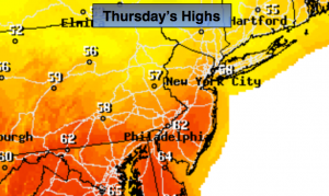
Today:
More clouds than sun. A sprinkle is possible. Spring-like. Highs in the upper 50s, 60s over Central and Southern NJ. Breezy. Southwest wind at 15-25mph.
Tonight:
A passing shower, otherwise mostly cloudy. Lows will be in the mid 40s in the City, the 30s inland. Southwest winds will become Northwest late and increase to 10-20mph with higher gusts.
Friday:
Partly sunny. The thaw continues. Highs in the mid to upper 40s. The average high for this time of the year is 38º.
Saturday:
Sun will give way to increasing clouds. Colder. Highs in the mid 30s. Chance of flurries or snow showers later in the afternoon and at night.
Sunday:
Mostly sunny and seasonal with readings in the upper 30s.
Monday:
Partly sunny with highs around 40º.
Stay Tuned.
Keep it here for a no nonsense, no hype forecast.