Synopsis:
Cold high pressure will move into the East coast today keeping the temperatures near or below freezing with a mix of sun and clouds.The good news here is that the cold snap will be short-lived. By Tuesday highs temperatures will recover. Winter arrives Wednesday at 5:44AM EST, the weather will be tranquil and seasonal. No major storms are on the horizon as we head into the Hanukkah and Christmas weekend. The weather will cooperate for travel through the 25th.
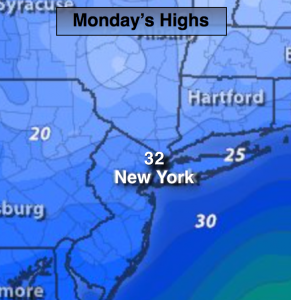
Today:
Partly sunny and cold once again. Highs only near freezing. Northwest to North winds at 8-12mph.
Tonight:
Clearing and very cold. Lows in the lower 20s in the City, single digits and teens inland. Light North wind.
Tuesday:
Sunny and not as harsh. Highs in the mid to upper 3os.
Wednesday:
Partly sunny and seasonal. Highs in the mid 40s.
Thursday:
Morning sunshine with give way to clouds and late day showers. Highs in the mid 40s.
Friday:
Mostly sunny. Highs in the mid 40s.
Stay Tuned.
Keep it here for a no nonsense, no hype forecast.