Synopsis:
High pressure will build into the region today resulting in a fine travel day as many return home from the long holiday weekend. It’ll be the cooler half of the weekend but will feature more sunshine. The workweek will start off tranquil. A series of low pressure systems will affect the region Tuesday through Thursday most likely resulting in two rounds of rain. The total rainfall has the potential to be significant, this will hopefully help the drought situation. Snow lovers you’re going to have to wait.
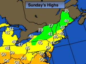
Sunday:
Partly sunny, cooler and breezy. Highs in the mid to upper 40s. Northwest wind at 10-20mph.
Tonight:
Mostly clear and cold. Lows in the upper 30s in the City, the 20s inland. Northwest wind at 5-10mph.
Monday:
Mostly sunny. Highs in the upper 40s to around 50º.
Tuesday:
Cloudy with rain developing during the morning. Mild. Highs in the mid to upper 50s.
Wednesday:
Mostly cloudy in the morning. Rain likely during the afternoon. Balmy. Highs in the upper 50s to around 60º.
Thursday:
Morning rain will give way to some late day sun. Mild. Highs in the upper 50s to around 60º.
Stay Tuned.
Keep it here for a no nonsense, no hype forecast.