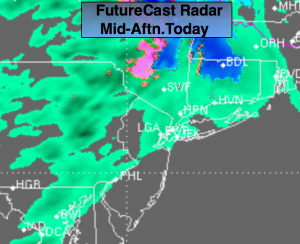
Synopsis:
A weak area of low pressure will move in from the Ohio Valley today. It will be just cold enough well inland for a mix of sleet and snow to fall at the onset. No major accumulations are expected. A coating of sleet and snow is possible over the Mid-Hudson Valley and the Catskills (FutureCast Radar above). Expect periods of rain elsewhere. Parts of Central and Southern NJ will be on the more intermittent and lighter side of the rain shield. Tranquil weather will close the week and a mild push is on the way for the weekend.
Today:
Periods of rain. The rain may start off as a mix of sleet and snow for a time well North of the City. Highs in the 30s & 40s inland the lower 50s at the coast. East to Southeast wind at 10-15mph.
Tonight:
Rain early. Skies will become partly cloudy late. Steady or slowly rising temperatures into the 40s and lower 50s. South to West wind at 10-15mph.
Friday:
Mostly sunny. Highs in the mid 50s.
Saturday:
Partly sunny and mild with readings in the mid 60s.
Sunday:
Partly sunny. A few showers are possible Highs around 60º.
Halloween:
Sunny and cool. Highs in the mid 50s.
Stay Tuned.
Keep it here for a no nonsense, no hype forecast.